Recognizing the signs of approaching bad weather is crucial for preparedness and safety. You often have visual and atmospheric clues that can alert you to changes in weather conditions.
Darkening clouds, changing wind patterns, and drops in temperature can all signal that bad weather is on the horizon. Understanding how weather systems develop and the science behind atmospheric indicators can help you anticipate severe weather events and take necessary precautions.
Watching the sky is one of the simplest methods to detect incoming bad weather. The shape, color, and movement of clouds can provide valuable information about the type of weather that is approaching. Moreover, fluctuations in atmospheric pressure, which can be observed through a barometer, often precede weather changes. Nowadays, technological tools, such as radar and satellite imaging, bolster our ability to predict bad weather with greater accuracy and provide warnings well ahead of time.
Listening to expert meteorological forecasts and staying informed about seasonal and climatic patterns relevant to your area are essential steps to understand what kind of weather events may impact you.
Recognizing signs of approaching bad weather, such as darkening clouds, shifting winds, and barometric pressure changes, is crucial for safety. These atmospheric indicators, along with technological tools and expert forecasts, help predict severe weather, allowing for timely precautions.
Understanding Weather Systems
When you’re trying to anticipate weather conditions, understanding the basics of weather systems is crucial. Professional meteorologists rely on a range of tools and principles to forecast weather, evaluating factors such as fronts, pressure systems, and barometric pressure to make predictions.
- Fronts: These are boundaries between air masses of different temperatures. A cold front occurs when a cold air mass moves into a warmer area, often producing stormy weather. Conversely, a warm front is when warm air replaces cold air, and while it may bring precipitation, the conditions are usually less severe.
- Pressure Systems: The shifts in air pressure greatly affect the weather you experience. A high-pressure system usually leads to clear, calm weather, while a low-pressure system can result in cloudiness and storms.
Your local National Weather Service is an essential resource; they use advanced technology to measure changes in barometric pressure and predict how these will translate into weather events. By monitoring changes in pressure, meteorologists can issue warnings for severe storms, which can save lives and property.
To understand the weather that’s heading your way, it’s helpful to familiarize yourself with these concepts:
- Air Pressure: It’s the weight of the atmosphere above us. Falling air pressure often precedes bad weather.
- Barometric Pressure: A barometer measures this pressure, which can indicate changes in the weather.
- Fronts: Knowing whether a cold or warm front is approaching can help you anticipate temperature changes and precipitation.
By keeping an eye on these elements, you can have a better grasp of the weather forecast and plan your activities accordingly. Remember, sudden changes in weather conditions can affect travel, outdoor activities, and your personal safety.
Atmospheric Indicators of Severe Weather
Recognizing atmospheric indicators can be crucial in predicting severe weather events. Paying attention to cloud formations, temperature and humidity variations, as well as wind patterns and direction, can provide early warnings signs of storms or adverse weather conditions.
Cloud Formations
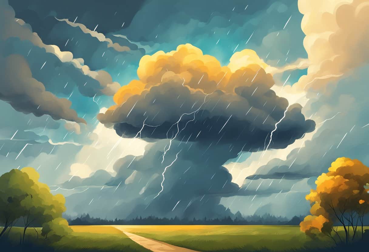
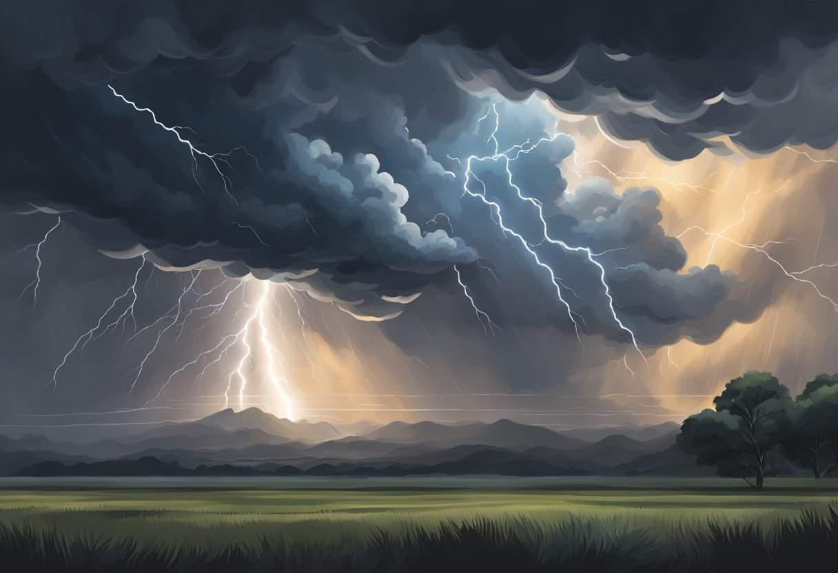
When you observe the sky, certain clouds act as harbingers of bad weather. For example, cumulonimbus clouds are tall, anvil-shaped formations that signify thunderstorms and could lead to severe weather like tornadoes or hail. On the other hand, High-altitude cirrus clouds can indicate that a change in the weather may occur within the next 24 hours. Unique cloud types like the lenticular clouds, which appear as lens-shaped formations typically found near mountain ranges, are signs of strong winds aloft. Arcus clouds are low, horizontal cloud formations that suggest the arrival of a thunderstorm front.
Temperature and Humidity Variations
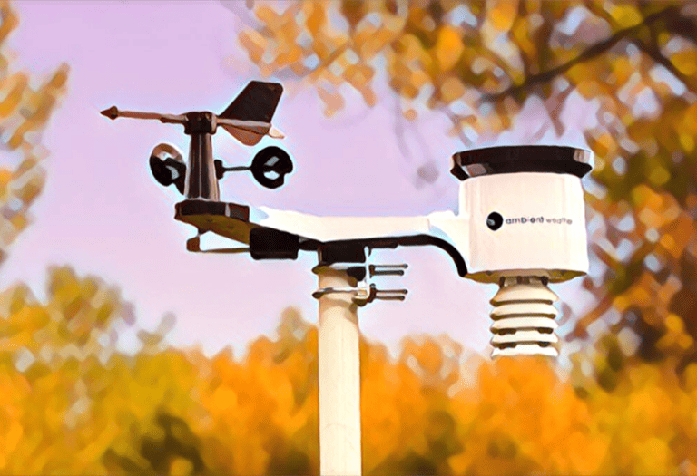
A sudden drop in temperature or a rapid rise in humidity can be a clear indication of an incoming storm. When these two conditions are coupled, the atmosphere becomes unstable, often resulting in a storm or severe weather. It’s useful to keep a tool, like a thermometer or hygrometer, handy to monitor these changes in your environment more accurately.
Wind Patterns and Direction
Noteworthy changes in wind patterns and wind direction often precede drastic weather changes. A sudden increase in wind speed or a shift in direction can signal an approaching storm system. Observing wind phenomena like a “cap” — a layer of warm air above cooler air — can help you predict thunderstorm formation. Pay attention to the presence of a wave cloud structure that can indicate atmospheric instability and possible storm development.
Reading the Sky and Precipitation
In anticipating bad weather, two key indicators can guide you: the visual cues from the sky’s color and movement, and the varied nature of precipitation. Understanding these signs helps you predict and prepare for potential inclement weather.
Color and Movement in the Sky
When you look at the sky, a broad spectrum of colors is often a clue. Dark grey or greenish clouds are usually a harbinger of heavy rain or hail. Fast-moving clouds suggest an approaching storm system, and if you witness cumulonimbus clouds, which tower high into the atmosphere, they may signal thunderstorms or even tornadoes.
Types and Intensity of Precipitation
Various precipitation types, from light drizzle to torrential rainfall, convey unique insights into weather patterns. If you observe light, intermittent rain, it could indicate a weather front with lasting, but less severe conditions. Conversely, sudden heavy rain or hail often precedes a more violent thunderstorm. During colder months, light snowfall can quickly evolve into a heavier snowstorm, so monitoring changes in intensity is crucial.
Keep in mind that the presence of lightning and thunder is a direct indicator of thunderstorms, which may bring severe weather including heavy rain, strong winds, and on occasion, hail.
By interpreting these natural signals, you’re better equipped to anticipate and react to the diverse forms of inclement weather.
Biological Responses to Weather Changes
As weather conditions shift, you’ll observe distinct biological responses from various species. Animals often exhibit unique behaviors, and plants react in particular ways to the changing environment, providing valuable clues about impending weather changes.
Animal Behavior
Birds often act as reliable indicators of bad weather. For example, if you notice birds flying lower than usual, it may be because air pressure is dropping, a sign that a storm could be approaching. Swallows swooping low to catch insects can mean the same as insects tend to fly lower during low-pressure conditions.
Another intriguing behavior is seen in ants; they build their mounds higher before heavy rain, perhaps to protect their colonies from flooding. Similarly, bees tend to stay closer to the hive in anticipation of adverse weather, especially when wind speeds pick up or barometric pressure drops. Observing your local fauna, you can often predict a change in weather based on these natural behaviors.
Plant Reactions
Your local flora provides a visible response to weather changes. Some plants, for instance, may close their leaves or flowers in anticipation of rain. This reaction is a protective measure, safeguarding pollen or reducing excess water retention that can lead to fungal growth.
The environment as a whole reflects these biological patterns. When plants and animals respond to weather, they are part of a larger ecosystem reacting to atmospheric changes. As such, your observations of flora and fauna can inform you about upcoming shifts in weather, allowing you to prepare accordingly.
Seasonal and Climatic Weather Patterns
When assessing weather patterns, you should consider both the current season and larger climatic trends to anticipate potentially severe weather. Each season has distinctive indicators that suggest an approaching storm or weather event.
Winter can often bring harsh conditions like winter storms. You may notice a significant drop in temperature and an increase in wind speed, suggesting a storm could be imminent. Moreover, low-pressure systems visible on weather maps can often lead to snowfall, blizzards, or ice storms during this season.
During spring and fall, tornadoes can be more prevalent, particularly in regions known as Tornado Alley. Signs of an approaching tornado include a sudden calm after a thunderstorm, a dark, often greenish sky, a loud roar similar to a freight train, and a visible funnel cloud.
Hurricanes and cyclones are tropical phenomena often occurring in the late summer and fall. You can spot early warning signs of these when there’s an unusual change in wind patterns, heavy swells on the ocean surfaces, and extended periods of rainfall as these systems develop over warm ocean waters.
Listed here are key indicators for each severe weather event:
- Winter Storms: Sharp temperature drop, wind speed increase, low-pressure systems.
- Tornadoes: Sudden calm, dark greenish sky, loud roar, funnel cloud sighting.
- Hurricanes/Cyclones: Wind pattern changes, ocean swells, prolonged heavy rain.
By understanding these patterns and indicators, you can better prepare for what the season may bring. Stay informed by following weather forecasts and understanding how seasonal trends can affect your local climate and weather events.
Assessing Extreme Weather Risks
In this section, you’ll learn how to spot the signs of imminent extreme weather and the steps necessary to ensure safety and minimize risks.
Identifying Potential Natural Disasters
When it comes to thunderstorms and severe weather, key indicators include a sudden drop in temperature, darkening clouds, increased wind speeds, and a rapid change in pressure. Specialized websites and news channels often provide a storm tracker that can alert you to the possibility of tornadoes or hurricanes approaching. It’s critical for you to stay informed through reliable weather forecasting tools and alerts when high winds or foul weather are forecasted to protect your property and plan any necessary travel with safety in mind.
- Thunderstorms: Look for towering cumulonimbus clouds, hear for the rolling sound of thunder.
- Tornadoes: Watch for a rotating, funnel-shaped cloud, listen for a loud roar similar to a freight train.
- Hurricanes: Monitor official weather forecasts, observe bands of heavy rain or swelling seas.
Safety Measures and Precautions
Once you’ve identified a risk, take immediate precautions. If a storm is imminent, secure outdoor items that could become projectiles in high winds. Inside, stay away from windows to avoid injury from shattered glass.
- Secure your property: Move vehicles to a garage and bring outdoor furniture inside.
- Have a safety kit: Include necessities like water, non-perishable food, first-aid supplies, and a flashlight.
- In case of tornadoes, seek shelter in a basement or an interior room on the lowest floor of a sturdy building.
In terms of travel, avoid it if a severe warning is in place. If already on the road when a thunderstorm begins, pull over to a safe location until it’s safe to continue. In the event of a hurricane, follow evacuation orders from authorities promptly and carefully. Your safety and the safety of those around you depend on these proactive measures.
Technological Tools for Predicting Weather
When you check your local weather forecast, you’re benefiting from a suite of technological tools that predict weather patterns. Understanding these tools can help you better anticipate changes in your local weather.
Satellites play a crucial role in weather forecasting. They provide meteorologists with real-time data on cloud coverage, storm development, and atmospheric conditions. Infrared and visible imagery from satellites can delineate cloud formations that may indicate an approaching storm.
Weather radars are another essential tool used to predict the weather. They detect precipitation, its intensity, and movement, which helps in predicting where and when rain or storms will hit. Doppler radar, with its ability to detect motion, can assess wind speed and direction, often providing early warning of severe weather such as tornadoes.
Weather stations scattered across the globe collect vital data on temperature, humidity, wind speed, and barometric pressure. This network of stations contributes to a database of local weather conditions, enhancing prediction accuracy.
Numerical models, which use mathematical formulas to simulate the atmosphere’s behavior, are fed with data from these tools. Advanced computer models analyze this data to produce weather predictions. Supercomputers run these models, extrapolating conditions to forecast future weather scenarios.
Lastly, Automated Surface Observing Systems (ASOS) operate continuously at airports and other locations. They offer frequent updates on many weather parameters, contributing to the ongoing assessments necessary for detailed and accurate weather forecasts.
By leveraging these technologies, meteorologists can provide timely and accurate weather forecasts, helping you plan and prepare for whatever the sky has in store.
Meteorological Phenomena
When you observe the sky and notice a halo around the moon, this is often a sign of an approaching weather change. This phenomenon is caused by the refraction, reflection, and dispersion of light through ice crystals suspended in the atmosphere. These ice crystals are usually associated with thin, high-altitude clouds like cirrostratus that often precede a warm front, suggesting that bad weather could be on the way.
Lightning strikes are another dramatic indicator of bad weather, specifically thunderstorms. These storms are formed when warm, moist air rises quickly and cools, creating a turbulent environment as the moisture condenses to form precipitation. The rapid movement of particles in the storm clouds often leads to the build-up of electrical charges, resulting in lightning.
Lastly, when you’re near coastal regions, pay attention to ocean waves. Scientists have identified a phenomenon called ‘swell waves’ which are consistent, long wave patterns that can travel vast distances from stormy areas to calmer seas. When you spot these well-organized waves rolling in, they might indicate that a storm is brewing far away, but powerful enough to affect ocean conditions.
By understanding these meteorological phenomena, you can gain insight into weather patterns and potentially predict bad weather before it arrives. Stay observant and use this knowledge to prepare for the changing skies.
Frequently Asked Questions
You can often predict impending bad weather through certain signs in your environment. Understanding these indicators will prepare you for necessary precautions.
What are common signs of an impending storm?
Darkening clouds, especially tall, towering cumulonimbus clouds, often precede a storm. A sudden drop in temperature and strong, gusty winds are also telltale signs of an incoming storm.
How might animals behavior indicate a change to worse weather?
Animals often sense changes in weather before humans do. Birds flying low to the ground and animals displaying restlessness or heading for shelter can signal that bad weather is approaching.
What differences between a weather watch and a weather warning should one be aware of?
A weather watch means conditions are right for severe weather to develop, while a weather warning indicates that severe weather is imminent or occurring, and you should take immediate action.
Which cloud formations might suggest that severe weather is imminent?
The sight of towering cumulonimbus clouds with an anvil shape or dark, rolling cumulus clouds can suggest that severe weather, such as thunderstorms or tornadoes, is imminent.
What meteorological changes occur when a thunderstorm is about to strike?
When a thunderstorm is about to strike, you might observe frequent lightning, hear thunder, notice a rapid drop in temperature and atmospheric pressure, and see increasing wind speeds.
In what ways do barometric pressure shifts hint at potential bad weather?
Falling barometric pressure often indicates that a low-pressure system is moving in, which can lead to cloud formation and precipitation. A rapid drop is commonly associated with stormy conditions.